Gatlinburg Weather Impact on Hiking: A Beginner’s Guide to the Smokies
You check the forecast from your cabin in town, see sunshine and 70 degrees, and head for a trail. An hour later you are standing in cold fog at 5,000 feet, soaked and shivering. That gap between the valley and the ridge is the whole story here. Understanding the Gatlinburg weather impact on hiking is what keeps a fun day from turning miserable, or worse. This guide walks you through what changes, why it changes, and how to plan around it as a beginner.
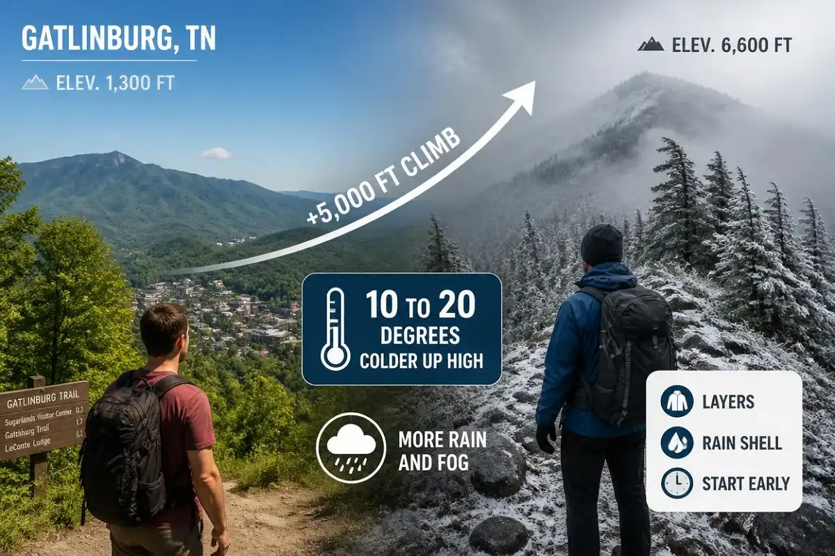
Weather in Gatlinburg shifts fast and gets far more extreme as you climb. High trails often run 10 to 20 degrees colder than town, with heavier rain, thicker fog, and stronger wind. So you plan by elevation, start early, pack layers and rain gear, and check both the valley forecast and the mountain forecast before every hike.
Why the forecast you see is only half the picture
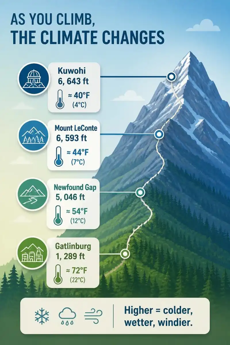
Gatlinburg sits low, at about 1,289 feet. The trails around it do not stay low. Many climb toward peaks above 6,000 feet, and that vertical rise rewrites the weather completely.
The town has a humid subtropical climate, which means warm, sticky summers and cool, wet winters. Once you gain elevation, though, the numbers change. Temperatures in the Smokies drop roughly 3 to 4 degrees for every 1,000 feet you climb. Stack that up over a long ascent, and the summit can feel like a different season than the parking lot. Wind adds to the chill, too. Exposed ridges and open summits catch gusts that the sheltered valley never feels, so the same air temperature bites harder up top.
Two high points show the range. Kuwohi (called Clingmans Dome until September 2024) tops out at 6,643 feet, the highest spot in the park. Mount LeConte rises to 6,593 feet right above Gatlinburg. On a warm valley afternoon, both can sit in cold cloud with a bite of wind. Locals have a saying: if you don’t like the weather, wait a day and it changes. On the trail, sometimes you only wait an hour.
Because elevation drives so much of this, it helps to know how climbing affects both your legs and the conditions around you. My notes on what counts as serious elevation gain pair well with weather planning, since the same climb that tires you out also drops the temperature.
Temperature drops as you climb higher into the Smokies.
High trails can be 10–20 degrees colder than town.
Higher elevations receive significantly more precipitation.
Fast-moving fog can reduce visibility to only a few feet.
Exposed ridges and summits can feel much colder than sheltered valleys.
Gatlinburg weather impact on hiking, season by season
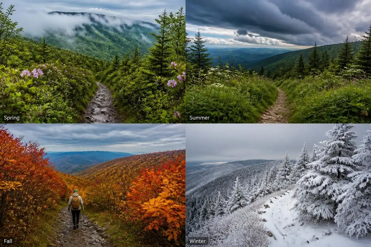
Each season brings its own version of the same problem: the mountains do their own thing. Here is what to expect through the year.
Spring — March to May
Spring is the trickiest season for the Gatlinburg weather impact on hiking. Town can hit the 70s while the high trails still hold snow and ice. March swings the most, with rain, sleet, or snow all possible in a single week. Wildflowers make it a beautiful time, yet mud is everywhere, and creek levels run high from snowmelt and rain. Fords that sit ankle-deep in fall can run thigh-deep in spring, so treat every crossing with care.
So bring a warm layer even when the valley feels like short-sleeve weather. My guide to layering for cold-weather trails helps here, because spring up high still acts a lot like winter.
Summer — June to August
Summer means heat, humidity, and near-daily afternoon thunderstorms. Warm, moist air rises over the mountains and builds tall storm clouds by early afternoon. Down in town it stays in the mid-80s. Up high it runs cooler, which is why the peaks feel like a break from the heat.
That heat and humidity can also drain you on the low trails, so drink more water than you think you need. Still, those storms are the real hazard, and I cover them below. For the lower trails, light and breathable clothing matters, so my tips on dressing for warm, humid hikes are worth a read first.
Fall — September to November
Fall is the sweet spot for many hikers, and I agree. Crisp air, low humidity, and famous color draw big crowds in October. Nights turn cool fast, though, and by mid-November light snow can dust the high peaks. So mornings need a jacket even when afternoons feel mild.
October crowds also fill trailhead lots early, so an early start helps twice, once for the weather and once for parking. Temperature inversions show up this time of year as well, where valleys sit colder than the slopes above them at dawn. Plan for a chilly start and a warmer midday.
Winter — December to February
Winter flips the whole park. Town lows drop into the 20s, and the high country turns harsh, with ice, packed snow, and biting wind. Newfound Gap gets around 69 inches of snow in a typical winter. Roads close often, too. Kuwohi Road shuts from December 1 through March 31, and Newfound Gap Road closes during storms because of snow and ice.
Daylight is short, so your window is tight. Trails are quiet and lovely, but this is the season that demands the most respect and the most gear. If you want lower, safer options, my roundup of cold-season trail picks can point you somewhere gentler.
Rain and fog: the two conditions that catch people off guard
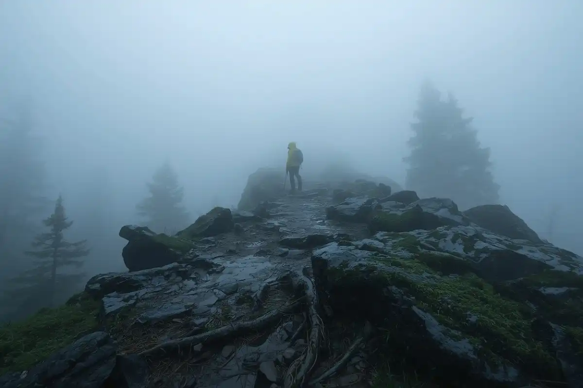
Rain defines the Smokies more than most visitors expect. These mountains are one of the wettest places in the eastern United States, in part because the peaks force damp air upward until it cools and falls as rain. Gatlinburg gets around 51 inches of rain a year. Climb toward the peaks, and that jumps to as much as 85 inches at the highest elevations. So wet trails are the norm, not the exception.
Expect wet trails
Higher elevations can receive substantially more rain than Gatlinburg. Wet rocks, roots and mud should be treated as normal trail conditions.
Fog is the other constant. Those blue-gray hazes are why the range earned its name. Fog rolls in fast, drops visibility to a few feet, and hides trail markers and drop-offs. On rock and root, wet also means slick, and a slip on a slick descent is one of the most common ways people get hurt here.
When fog closes in, slow down, keep the trail underfoot, and check your map often, because a wrong turn is easy once you cannot see the next marker.
Thick fog can hide trail markers, drop-offs and the next section of trail.
Wet rocks, roots and steep descents require slower, more deliberate footing.
Heavy rain can make creek crossings rise quickly and become unpredictable.
If water is rushing over a crossing, do not attempt it.
Heavy rain adds a bigger danger: flash flooding. Creeks that look calm can rise fast during a storm. Park rangers warn against backcountry travel when crossings turn unpredictable, and for good reason. If water is rushing over a crossing, turn back. A wet crossing is also where trekking poles earn their keep, and my take on whether poles are worth carrying explains how they steady you on uneven, slick ground.
Summer storms and lightning
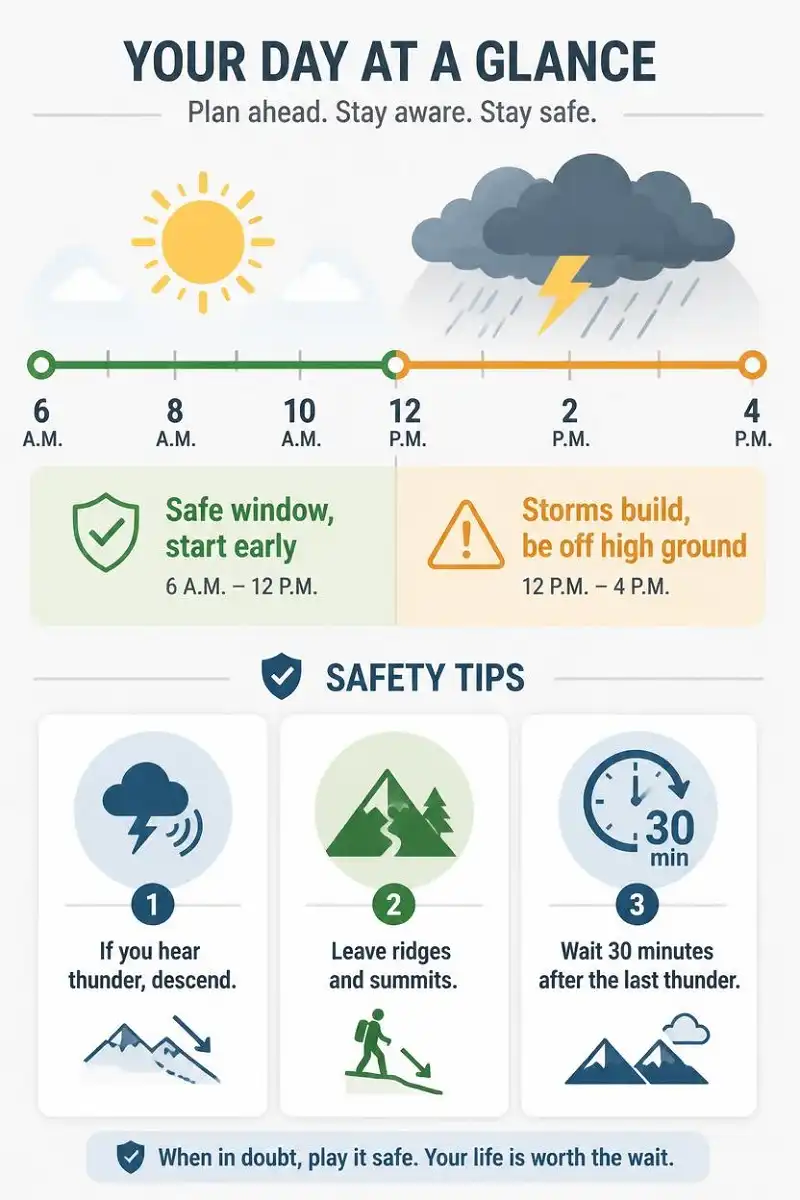
Afternoon thunderstorms are the single biggest weather risk for summer hikers. In the mountains, storms tend to build in the early afternoon. So the fix is simple: start early, and aim to be off high, exposed ground by around noon.
⚡ Lightning rule
If you can hear thunder, you are already close enough to be struck. Lightning can reach more than 10 miles from a storm, well past the sound of thunder.
When one moves in, get off ridges, summits, and open overlooks, then drop to lower ground and tree cover. After that, wait at least 30 minutes past the last thunder before you head back up.
Why cold, wet, and wind add up to real danger
Cold alone rarely gets beginners into trouble here. The bigger threat is cold combined with wet and wind. A soaked hiker in a stiff breeze can shed body heat fast, even when the thermometer reads well above freezing. So hypothermia is a serious risk on high Smokies trails in spring, fall, and even during a stormy summer afternoon.
Persistent or intense shivering can be an early warning that the body is losing heat.
Difficulty handling gear can signal that you are becoming too cold.
Speech changes should be treated seriously and followed by immediate warming measures.
Confusion or slowed decision-making is another reason to stop and warm up.
Watch for the early signs in yourself and your group: heavy shivering, clumsy hands, slurred words, and slow thinking. Once those appear, warm up right away. Get out of the wind, swap wet layers for dry ones, add insulation, and eat something with calories.
Better yet, head it off early. Keep a dry layer sealed in your pack, pull your rain shell on before you are soaked, and turn back when the conditions pile up.
How to plan around the weather
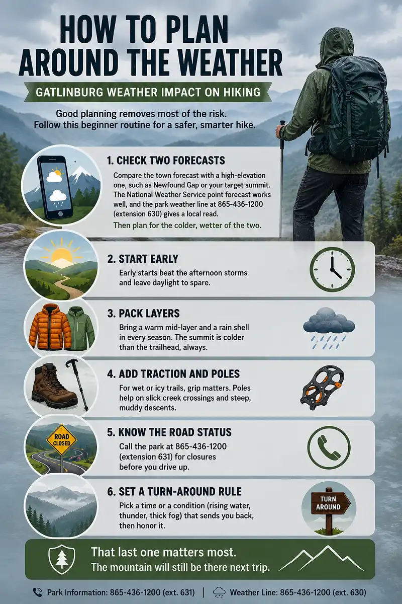
Good planning removes most of the risk. Here is the beginner routine I follow for the Gatlinburg weather impact on hiking.
Compare the town forecast with a high-elevation one, such as Newfound Gap or your target summit.
Early starts beat the afternoon storms and leave daylight to spare.
Bring a warm mid-layer and a rain shell in every season.
For wet or icy trails, grip matters. Poles help on slick creek crossings and steep, muddy descents.
Call the park at 865-436-1200 (extension 631) for closures before you drive up.
Pick a time or a condition that sends you back, then honor it.
The most important planning rule
Set a turn-around rule before you start. Pick a time or a condition (rising water, thunder, thick fog) that sends you back, then honor it. That last one matters most. The mountain will still be there next trip.
The National Weather Service point forecast works well, and the park weather line at 865-436-1200 (extension 630) gives a local read. Then plan for the colder, wetter of the two.
What to pack for changing conditions
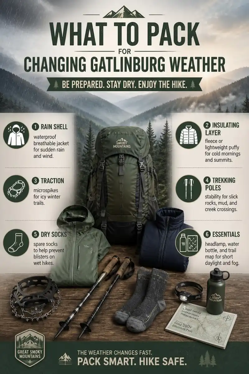
Your pack does the heavy lifting against the Gatlinburg weather impact on hiking. A few core items cover almost every situation.
- Rain shell: a waterproof, breathable jacket for sudden rain and wind up high.
- Insulating layer: a fleece or light puffy for cold summits and cool mornings.
- Traction: microspikes for winter ice on the high trails.
- Trekking poles: stability on slick rock, mud, and creek crossings.
- Dry socks: a spare pair keeps blisters away on wet days. Good socks help too, and my notes on why sock choice matters explain the difference.
- Headlamp, water, and a map: short winter daylight and thick fog make all three worth carrying.
You do not need expensive gear to start
Instead, pack the right categories every single time, and upgrade as you go.
How Weather Impacts Hiking in Gatlinburg
Weather is the one thing that decides how a Smokies hike goes. The valley forecast tells you almost nothing about the ridge, so read both, start early, and pack for the colder, wetter version of the day.
Respect the afternoon storms in summer and the ice in winter. Do that, and the Gatlinburg weather impact on hiking becomes something you manage instead of something that ruins your trip.
The mountains reward the hikers who plan.
FAQs
What is the best month to hike in Gatlinburg?
October is a favorite for mild, dry days and fall color, though it draws crowds. Late spring and early fall both offer comfortable conditions, as long as you respect the Gatlinburg weather impact on hiking at higher elevations, where the air stays cooler.
Does it snow in Gatlinburg?
Yes, mostly in the high country. Town gets occasional light snow, but the peaks see far more. Newfound Gap alone averages about 69 inches per winter, and snow can linger on high trails well into spring.
Can weather close the trails or roads?
Yes. Storms, ice, and flooding all close roads and make trails unsafe. Newfound Gap Road closes during winter storms, and Kuwohi Road shuts from December through March. So always check road status before you go.
Is it safe to hike in the rain here?
Light rain is fine with a rain shell and careful footing, since these trails are wet so often. Heavy rain is a different matter. It makes rocks slick, swells creeks, and raises flash-flood risk, so skip exposed or creek-heavy routes when a downpour hits. When in doubt, pick a shorter, lower trail.
How much colder is it at the top?
Plan on 10 to 20 degrees colder than town at the highest elevations, plus wind. That gap is the core of the Gatlinburg weather impact on hiking, and it surprises first-timers the most.